 "TheRealBicycleBuck" (therealbicyclebuck)
06/08/2020 at 09:56 ē Filed to: None
 1
1
 28
28
 "TheRealBicycleBuck" (therealbicyclebuck)
06/08/2020 at 09:56 ē Filed to: None |  1 1
|  28 28 |
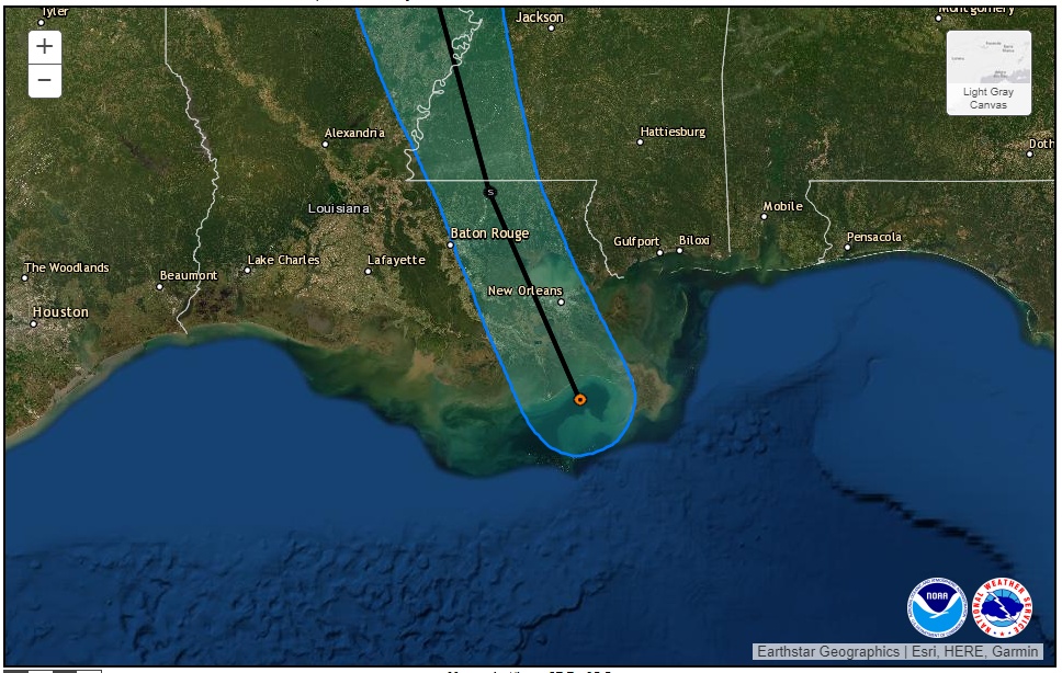
Despite tracking just east of us, Cristobal didnít do us much harm. We still have to wait and see if there will be any flooding, but it looks like weíll be ok right now.

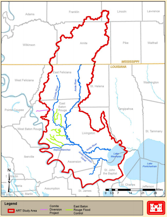
The Baton Rouge area is funny when it comes to flooding. The Mississippi River runs right by downtown, but with a very robust protection system from the levees, most people arenít concerned about the Mississippi. The bigger threat is the Amite river, a drainage system that extends into Mississippi (the state) and is almost completely uncontrolled. It was rainfall in the Amite basin that caused extensive flooding back in 2016.

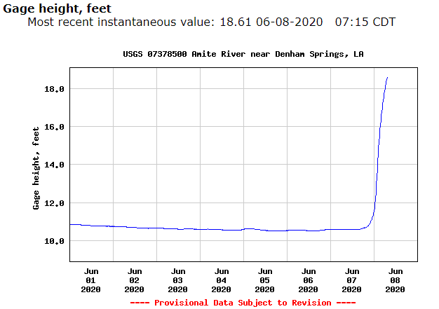
So far, the stream gages on the Amite are climbing, but it doesnít look like Cristoba l dumped enough rain to be a major concern.

The 2016 flood was caused by 20-30 inches of rain across the Amite basin. It doesnít look like Cristobal dropped anywhere near that. A quick survey of gages shows it dropped 2-4 inches of rain in the basin. Areas further east of us received more rain and to the southeast, storm surge along with the rain led to some flooding. Cristobal is still predicted to drop up to 10" of rain in some areas and that can lead to more flooding, but it looks like we dodged another bullet. Unfortunately, the season is just getting started.
Good luck to those folks still in the path.
 MasterMario - Keeper of the V8s
> TheRealBicycleBuck
06/08/2020 at 10:08 |
|
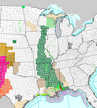
I hadnít paid much attention to any weather news and hadnít heard about this storm until I opened the National Weather Service page this morning at work.

Clearly something is heading up the middle of the US.
 ttyymmnn
> TheRealBicycleBuck
06/08/2020 at 10:11 |
|
Glad youíre safe. We could have used some of that rain. As it is, we are expecting highs over 100 tomorrow, due in part to Cristobal (something about sinking air on the west side of such a big low pressure system). We could use some of that rain.†
 TheRealBicycleBuck
> MasterMario - Keeper of the V8s
06/08/2020 at 10:14 |
|
Yep. Thatís the projected path for Cristobal.
 TheRealBicycleBuck
> ttyymmnn
06/08/2020 at 10:15 |
|
Thanks. If youíre willing to pay for shipping, I can start sending you buckets filled from the neighborhood pond.
 Rusty Vandura - www.tinyurl.com/keepoppo
> ttyymmnn
06/08/2020 at 10:29 |
|
46 degrees here when we got up this morning.
 ttyymmnn
> Rusty Vandura - www.tinyurl.com/keepoppo
06/08/2020 at 10:37 |
|
ďThe coldest winter I ever spent was a summer in San Francisco.Ē
óMark Twain (att.)
 Rusty Vandura - www.tinyurl.com/keepoppo
> ttyymmnn
06/08/2020 at 10:38 |
|
I needed a jacket.
 WasGTIthenGTOthenNOVAnowbacktoGTI
> ttyymmnn
06/08/2020 at 10:50 |
|
Itís supposed to be 93 here today. And here is Minnesota, so you know things are getting crazy.
 ttyymmnn
> WasGTIthenGTOthenNOVAnowbacktoGTI
06/08/2020 at 10:54 |
|

 horizonsofkhaos
> TheRealBicycleBuck
06/08/2020 at 11:04 |
|
Weíve already had a couple tropical systems graze us on the coast of NC this season. If thatís the extent of our activity thatíll be awesome but I seriously doubt that. Glad to see Cristobal didnít do too much damage to your region. Now to wait out the rest of the season and see what activity churns up.
 TheRealBicycleBuck
> horizonsofkhaos
06/08/2020 at 11:20 |
|
Thanks. This is the season for OppoWatch.
 Stef Schrader
> TheRealBicycleBuck
06/08/2020 at 11:36 |
|
Glad youíre safe from the worst of it. The combo of garbage weather on top of everything else is, ugh. Iím extremely over this year.
 HoustonRunner
> TheRealBicycleBuck
06/08/2020 at 12:12 |
|
Be safe, we watched it closely last week here in Houston, but ended up lucky. I f you recall some of my posts Iím no stranger to flooding. Though like ttyymmnn we could use (some of) the rain now. We have a great site in Houston https://spacecityweather.com/ that delivers on their tag line of ďhype-freeĒ forecasts.††
( I know you are somewhat familiar with Ho uston - I live in Meyerland, two streets south of Braes Bayou.)
 TheRealBicycleBuck
> HoustonRunner
06/08/2020 at 12:35 |
|
Thanks. I like the website. I wish we had something similar.
When I was little, we lived near the southeast corner of the loop. As an adult, I lived in the cypress area.
Are you within the 100- or 500-yr flood plains? If so, has your house been elevated?
 HoustonRunner
> TheRealBicycleBuck
06/08/2020 at 13:03 |
|
Yes and yes. †We are about 6 feet up, and Harvey came within about 8-10 inches. †WAY closer than I ever thought possible when we built in 2016.
 TheRealBicycleBuck
> HoustonRunner
06/08/2020 at 13:14 |
|
Dang, that is close!
Iím not sure what the City of Houston regs are now, but in the County, the new height requirement is last flood elevation plus two feet. That was put in place after Harvey.
When it flooded here in 2016, we still had at least two feet, probably closer to three, to go before it would have come into the house. It still spooked us.
We expect to relocate in the next few years. We are definitely moving uphill.
 HoustonRunner
> TheRealBicycleBuck
06/08/2020 at 13:30 |
|
When we built it was 1 foot above Base Flood Elevation, which was the 100 year mark. I pushed for higher, but was vetoed by my wife, so we are about 18 inches above instead of one foot. About 1 in 10 of the raised houses in Meyerland are a full floor (10 to 12 feet) high, with garages underneath.
The county flood mitigation project in our area has definitely accelerated since Harvey. †It had started prior, but was moving at a glacial pace. †Since Harvey they are almost back on schedule, with the bayou widened from about 1.5 miles upstream of me all the way to the med center. †The bridges are the bottleneck now, those are still moving slow.
 TheRealBicycleBuck
> HoustonRunner
06/08/2020 at 13:42 |
|
If itís on the bayou, itís a Harris County F lood Co ntrol D istrict project. Itís confusing, but the FCD , even though itís under the auspices of the County, is separate from the Engineering department. The bridges can fall under either the FCD or Engineering. Road & bridge projects outside the 100-yr flood plain typically fall under Engineering even though they are subject to flooding. Part of my work while I was there was coordinating projects between the two entities.
 HoustonRunner
> TheRealBicycleBuck
06/08/2020 at 14:11 |
|
Well, then I owe you a ďthanksĒ.† Project Brays has been moving along well.
 TheRealBicycleBuck
> HoustonRunner
06/08/2020 at 14:25 |
|
Nah, you donít owe me anything. If you say thanks to anyone, it should be the FCD guys. Theyíre the ones what will have the greatest impact on your situation. I just checked the website and it looks like even the bridge improvements are being handled by them on Brays Bayou. https://www.hcfcd.org/Find-Your-Watershed/Brays-Bayou
So if the bridge improvements arenít going fast enough, you know who to blame. ;)
 HoustonRunner
> TheRealBicycleBuck
06/08/2020 at 14:39 |
|
Overall I find the HCFCD to be pretty well run (or their media group is good). They are transparent and present the info they have in a consumable format. It doesnít hurt that the HCFCD Meteorologist (Jeff Lindner) is great on camera.
 TheRealBicycleBuck
> HoustonRunner
06/08/2020 at 14:49 |
|
There are some folks over there that are a total pain in the ass to work with, but they are behind the scenes. They look out for themselves first and either actively refuse to cooperate with other agencies or do it indirectly by just not answering emails or phone calls.
Thatís a problem in general with Harris County. The departments within the county are independent and thereís little cooperation between them. Itís a reflection of the districts and their ďme firstĒ attitude. When we were working on the early recovery efforts, I intentionally left the districts out of the supporting data so the decision makers could focus on recovery instead of the between-district politics. It didnít take long before the districts started squawking about how funding was going to be distributed. I had to go back and show how each district would be fairly compensated based on the amount of damage within the district. It was like working with a bunch of 3-yr-olds.
 jminer
> TheRealBicycleBuck
06/08/2020 at 16:29 |
|
Up here in Missouri rivers are already pretty swollen but weíve had a dry few days so that has helped dry the ground out.
The storm looks like it is tracking right up the Mississippi and if it dumps a ton of rain like theyíre predicting we may see major flooding.† Luckily it has been a relatively dry spring or weíd be screwed.
 TheRealBicycleBuck
> jminer
06/08/2020 at 17:05 |
|
I hope things go well for you. Weíll see that water as it comes down the Mississippi River, but theyíll open the Bonnet Carrť Spillway or if it gets really bad, the Morganza Spillway. The former dumps the river into lake Pontchartrain. The latter is a bigger deal since it floods the Atchafalaya basin.
As part of the monitoring team, I watched as they opened t he Morganza in 2011. the pressure on the levees was high enough to cause water to move through underground sand lenses and create sand boils on the protected side. That had the potential to undermine the levee. If youíve never seen or heard of a sand boil, this is a pretty good explanation.
T h e 2011 floods were exacerbated by heavy winter snows and lots of spring rainfall. The extra meltwater had us wondering if the levees could really hold. Iím sure if you lived in Missouri at the time, you remember 2011.
 jminer
> TheRealBicycleBuck
06/08/2020 at 17:36 |
|
Hopefully you all stay high and dry too.
I definitely remember 2011. Weíve had 3 500 year floods in the last 10 years here. One of our big issues is that basically everything from the suburbs in on the major Mississippi tributaries has been contained with levees which causes big problems for those living upstream of them since the river doesnít drain like itís supposed to anymore. It was a big story 2 years ago with our last big flood that reportedly several of the levees got built a few feet over spec as well.
Last year was an insane one on the Missouri river, with big snows and large rains it stayed a flood stage all summer long. Farms were hit hard as a lot of them were underwater through July.
Iíll be alright as we live up on top of a large hill but if it gets bad we can get stuck at home with all the roads within a few miles of our house closed. That no longer sounds that bad since weíve essentially been leaving the house once a week for groceries for the last 3 months now...
 TheRealBicycleBuck
> jminer
06/08/2020 at 18:52 |
|
Thanks.
Everyone is learning that forcefully containing the rivers is bad for everyone. As you noted, it causes the water to backup, it also increases the flow rate downstream. An unexpected side effect is the distribution of silt. The water flows so fast that when the Mississippi empties into the Gulf, the sediment itís carrying gets pushed into deep water. The longshore currents that normally replenish the marshes and beaches canít pick up the sediment, so the marshes and beaches west of the Mississippi have been eroding away. This affects beaches as far away as Galveston.
This story being related to me by one of my undergraduate professors eventually led to me going back to school to study broad-scale problems. I believe that we will eventually remove a lot of the levees and let the lowlands absorb the floodwaters as they did before we built levees. The farmers will have to deal with the occasional flood, but their soils will be enriched naturally and one bad year will lead to bumper crops the next. Instead of spending millions on levee construction and maintenance, weíll use the funds to compensate farmers during flood years.
Iíd like to hear more about the levee built higher than spec. Itís normal practice to build high so that when the materials finally settle, the final height matches specification. Iím guessing that the controversy was that a neighboring community complained that their levee would be overtopped before the new one would. We hear that all the time.
My favorite mistake was the contractor who used the wrong vertical datum and built his section a couple of feet too low. There are some places where the levee is designed to be low so if itís going to overtop, it happens in a location where life and property loss is minimized.
Federal l evees are inspected roughly every four months: before flood season, after flood season, before a flood, after a flood, and not to exceed four months. When the corps does their inspections, itís usually from inside a truck traveling at 45 mph on top of the levee . They have inspection reports which point them to the trouble spots and they will slow down there and sometimes even stop to take a closer look.
I was riding with the inspection team in NW Louisiana when we came across one of those low spots. The corps guy told me that he was riding with a fellow who didnít know it was there and didnít slow down before the levee dropped away. He said they nearly wrecked the truck and almost rolled down the levee. Thereís a smooth transition between the heights, but itís not meant to be traversed at speed. I imagine they felt like they were running the baja that day.
 jminer
> TheRealBicycleBuck
06/08/2020 at 19:08 |
|
Hereís an article about the Valley Park levee that was apparently built way overspec.
I grew up outside of flood protection and about half a mile away from the Meramec (a fairly large tributary to the Mississippi) and it flodded every spring into the hay fields surrounding it and we all lived with it. Most of the places closer to St Louis than me that were flood plain 20 years ago had a levee built and now are either commercial real estate or s ubdivisions . Itís insane.
I grew up there before most of the levees were built here and it flooded but unless it was a record year it also retreated quickly.† Once the levees went up it floods higher and longer (my mother still lives there).† Large sections of the town I grew up near had to be rezoned as flood plane and torn down because of it.
I hope youíre right and we finally come to a reckoning about flood management but there are precious few signs of it happening that I can see. Rural and farming communities donít have enough political sway to force politicians to do anything different and theyíre getting enriched by the real estate booms that new levees cause.
I love the story about levee inspection!
 TheRealBicycleBuck
> jminer
06/08/2020 at 21:30 |
|
Awareness and the ready availability of information are going to start changing that equation. Maintenance on levees is paid for by local taxation. Although they may get federal funding to assist in the construction of new levees, it wonít be long before politicians realize that residential taxation cannot support either the long-term maintenance of the levees or even basic city services. Since many of my students were likely to go on to work for a municipality, one of the lessons focused on analyzing revenue and cost of services for the annexation of a residential neighborhood. Even one without the additional cost of levee maintenance resulted in a net revenue loss to the municipality. The only thing that makes those kinds of developments feasible is retail, commercial, and manufacturing space.
I also think we are running up against some hard barriers when it comes to agriculture. Much of the value in row crop production is being driven by irrigation. R evelations about how agricultural pumping is draining the same aquifers we rely on for drinking water is already leading to restrictions on pumping. Eventually, there will be more long-term profit to be made by farming areas where soils are rich and water is plentiful rather than developing that land into subdivisions. Regulations p lay a major role in that and I think it wonít be long before regulations drive the cost of farming in dry areas higher than farmers are willing to pay . If the regulations change to account for the risk for farming in flood-prone areas, we should see some major shifts in crops to areas where irrigation cost is low.
Part of the solution is redirecting growth to areas which arenít prone to flooding in the first place. FEMA is already looking to minimize recovery dollars. Right now they are doing it by encouraging resiliency through mitigation programs. If you donít take steps to make the property more resilient, then FEMA will refuse to help after the next flood. They are building the databases to keep track of payouts on every property. Thatís part of what I was working on in Houston over the last two years.
Long-term thinking and long-term profits are slowly taking over the real-estate game. It will be driven by regulations and those will be changed †by people who are tired of paying for repeated losses. It has already started in the mitigation and recovery communities. As the losses get more frequent and of a greater magnitude, the insurance costs are going to drive rates up to the point where itís fiscally impossible to build in a flood plain. Itís already happening in coastal areas. Areas prone to riverine flooding will be next.